Cycl’Assist 0.3 is out!
Posted on October 22, 2018 in Dev • 3 min read
Cycl’Assist aims to be a webapp to ease tracking and reporting issues with bike infrastructures while riding your bike (any danger on the way such as holes in the ground, cars parked like sh*t, road work, etc). You can think of it as Waze for bikes :) Version 0.3 is now out and live at https://cyclo.phyks.me/! Here is a list of the main new features.
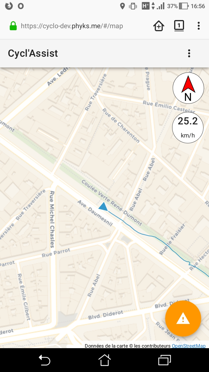
Speed badge
First of all, this new version now features a speed badge so you can get an estimate of your current speed. Speed is provided by the GPS interface so it is only displayed if you enabled geolocation. Note that this speed might not accurately reflect your current speed (especially at low speed or in urban areas) due to the way it is acquired from GPS data.
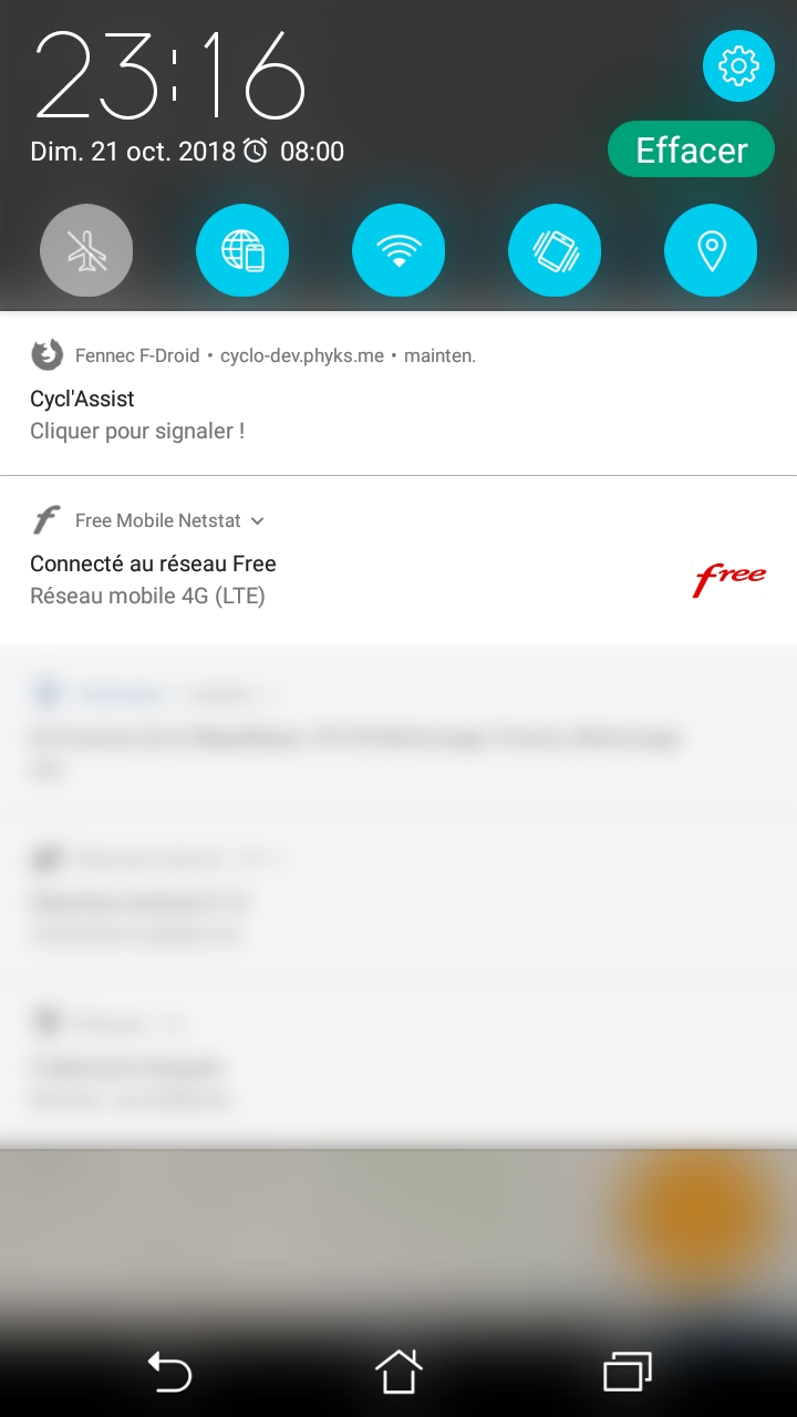
Permanent notification
This version introduces a new setting to display a permanent notification whenever Cycl’Assist is running in a tab. If you move to another tab or change app on your phone, you can click the notification at any time to be sent back to the new report window and send a report at your current location!
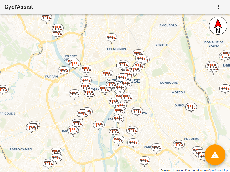
Importing OpenData about roadworks
Quite a lot of cities and local administrations around France are providing OpenData for roadworks. This is the case for:
- Lille,
- the Département du Loiret
- the Métropole de Lyon
- Montpellier Méditerranée Métropole
- the Grand Nancy
- Paris
- Rennes Métropole
- the Département de la Seine-Saint-Denis
- Sicoval (South-East of Toulouse)
- Toulouse Métropole
- Versailles Grand Parc which has three different datasets: Road Blocks, Road Closures and Road Detours
Note that this list might not be exhaustive but these are all the roadworks OpenData I could gather in metropolitan France so far. All of these are now imported on a daily basis on https://cyclo.phyks.me/. Feel free to reuse the OpenData import script for your own projects!
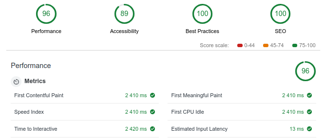
Faster loading
Cycl’Assist is meant to be mostly used on the go, on your phone. Then, you might not always have the best mobile connection available. Cycl’Assist is doing its best to perform well even if you are running on a slow 3G conection. In this version, some work was done to reduce the weight of the webpage while providing always more features. For the developers interested in this part, I wrote another blog post a month ago :)
The app should also perform better generally through small enhancements such as keeping only the nearby reports to avoid loading the memory of the device too much.
For the developers, an enhanced API
This new version comes with an enhanced API with some filtering capabilities. In particular, you can now export all reports from a given geographical bounding box using an API call to
> GET https://cyclo.phyks.me/api/v1/reports?filter[lat][gt]=LAT_MIN&filter[lat][lt]=LAT_MAX&filter[lng][gt]=LNG_MIN&filter[lng][lt]=LNG_MAX
For instance, here is an extract of all reports around Paris. The full API documentation is available here.
And some minor bug fixing and few small enhancements
- Upvotes on GCUM (poorly parked) cars now reset the expiration delay.
- There was a bug in the manual address selection when it would sometimes not send you to the picked location. This is now fixed.
- Sometimes the tips of the markers was slightly off, this is now fixed and the tips of the markers should point to the exact location of the report.
- More documentation has been written.
- Still available in English, French and Occitan (thanks to @Quenti)!